If you’ve ever wanted to visit outer space, some places in this park will make you feel like you actually landed on another planet. Drive your car around the edges of the cliffs and gaze down into one of the most unique canyons you’ll ever see; its rusty red walls accented with a rim stained white almost as though it were bleached that way. Ponder the path that led you here, at this moment, and imagine dinosaurs roaming the land or the indigenous people that called this home long before today. How could anything survive here? How did this massive work of natural art come to be?
Canyonlands National Park (link to official park map) sits just to the west of the city of Moab, Utah and Arches National Park. With four unique areas to explore, visitors can either live out their dreams from the comfort of their car’s climate control, up close under the blazing desert sun on foot or bicycle, or rolling in an off-road vehicle through the rough roads deep down in the canyons.
The most commonly visited region of the park is from the north entrance, accessible to the northwest of Moab. Services within the park are limited to its Visitor Centers and the occasional pit toilets at the trailheads or parking areas. There is no food for sale in the park, so bringing your own food is necessary if you are spending the whole day there. Reception is spotty and unreliable, and carrying a park map (offered complimentary with your entrance fee) is an absolute necessity. If you go without a specific plan, head to the Island-in-the-Sky Visitor Center during operating hours and talk to a park ranger about your options. They are there to help you make your adventure the best they can, but be mindful as to not take up too much of their time so they can help other people, too!

When to go and how long
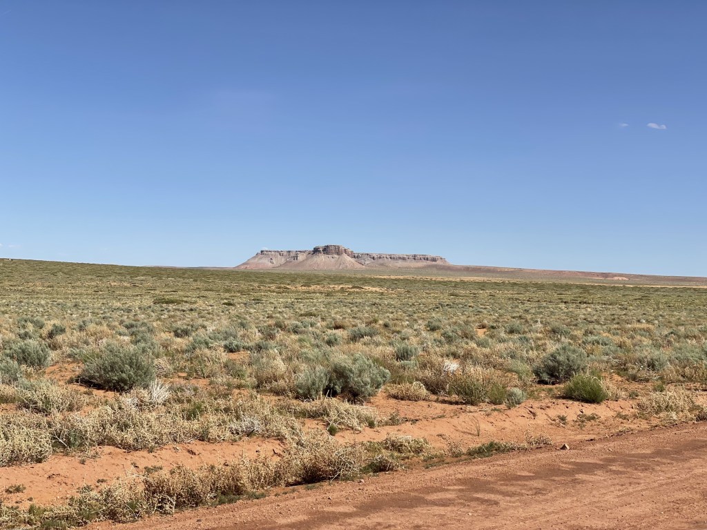
The desert can be blistering hot in the summertime, although it does still bring in significant crowds (likely due to school not being in session). I would not recommend strenuous activity (like long hikes) on those hottest days unless you embark before or around sunrise. May and June would definitely be preferable to July and August. Spring and fall are far more enjoyable because temps are more mild, but this is no secret as it is also busy during these times of the year. Winter temps are often below freezing, especially after the sun goes down, but during the daytime it can be windy and somewhat warm. The area rarely sees snow, although it’s definitely cold enough for it. It doesn’t get much precipitation at all during any time of the year. There is very little vegetation in the area except for near the rivers, so seasonal changes to the landscape are minimal (but still beautiful). Spring and summer can be pretty green, fall usually has lots of golds, and winter is mostly barren and brown.
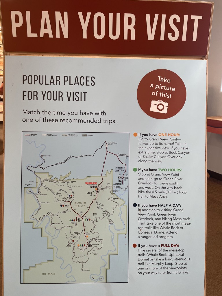
The main park consists of three major “districts” (Island in the Sky, Needles, and The Maze), plus one additional satellite region (Horseshoe Canyon). Allot yourself at least a day for each one you visit. It would be very difficult to try to do more than a single one in a day because the access points are not close to each other and the activity opportunities in each area are very different. The Island-in-the-Sky and Needles entrances are located on the Moab side within an hour of the city. Horseshoe Canyon and the Maze are extremely remote and must be accessed from the west side of the park.
Where to stay
Canyonlands has many camping opportunities available for reservation or permit in various areas of the park, but some will require a high clearance vehicle or backcountry experience to get to. I would recommend something different depending which part of the park you plan to visit.
Major campgrounds with basic amenities available within Canyonlands National Park are as follows:
- Willow Flat (Island in the Sky) is a first come, first served campground near the Green Valley overlook area, $15 per night. There are 12 total sites here.
- Needles District Campground has some sites that can be reserved up to six months in advance, and other sites are first come, first served. Price varies by size of the campsite and number of people in your group, with the most basic sites starting at $20.
The most frequently visited district is Island-in-the-Sky. There are other camping spots near this region in Dead Horse Point State Park, which offers a campground with a variety of sites (tent-only, RV hook-up, and yurts).
Moab is the largest and best city to lodge in (and if you are planning your trip from that area, you can take a look at my more detailed post about Moab specifically here, and there are many other campgrounds in the surrounding areas. If you haven’t visited this part of Utah before, I would also recommend planning a visit to Arches National Park, my post on that is linked here). This entire region is a very popular area for outdoor adventuring. For accommodation a bit further away, Green Valley may be a good option for you if you don’t mind a little extra driving.
If you end up in the park after dark, camping or otherwise, be sure to look up at the sky for some incredible stargazing!

Backcountry Camping Permits
There are tons of unnamed sites and zones off the beaten path for primitive camping, but will require backpacking, a bike or a high clearance vehicle to access. All backcountry sites inside the park require a permit (specific instructions can be found here). These must be obtained in advance, and some walk-up permits are available from the visitor centers and ranger stations. Operating hours and contact information for obtaining permits by phone and email can be found on the Canyonlands National Park website’s page titled Operating Hours & Seasons.
Take a look at the maps linked below (available by district directly from the national park website) to learn about the location of these remote campsites:
- Island in the Sky map / Island in the Sky Backcountry map
- Needles map / Needles Backcountry map
- The Maze map
- Horseshoe Canyon map
How to get around
You are most likely driving yourself. With a regular, 2WD vehicle, you are pretty much going to be limited to the Island-in-the-Sky district. For the most part, all other areas of the park require a 4WD/high-clearance vehicle and/or a bike to explore unless you plan on backpacking the backcountry (for which in many cases you may be parking at a 2WD accessible trailhead, but do check the map according to your specific plans in advance). Make sure you have at least a half-full tank of gas before you go, as there are no fueling stations inside the park.
There are no shuttles or public transportation options in the park, although for a price you can participate in guided tours from private sellers, mostly departing from Moab where all your transportation would be included. This is a fantastic option for those who have a larger budget, don’t have a car, and just want to sightsee, because the private tours take care of everything for you and bring you to a lot of the best spots! They do know these areas best…
Money
Aside from paying for park admission, campsites and permits, there really isn’t anywhere else for you to spend your money inside the park aside from the gift shop.
Any private tour company will on average charge a couple hundred dollars at a minimum for a half day of touring this area, or close to double that for a full day. There are plenty of different companies with offerings to choose from.
There is no food for sale in the park! It is recommended that you pack a lunch and snacks if you are planning to stay out there for a full day. (Private tours may include this for you.) The nearest restaurants and grocery options are located in Moab for Island-in-the-Sky and Needles, although there is one cafe about a half hour’s drive from the Island-in-the-Sky Visitor Center at the Moab Giants dinosaur museum. The small cities of Hanksville and Green River are the closest businesses to the entrances of the Maze region and Horseshoe Canyon.

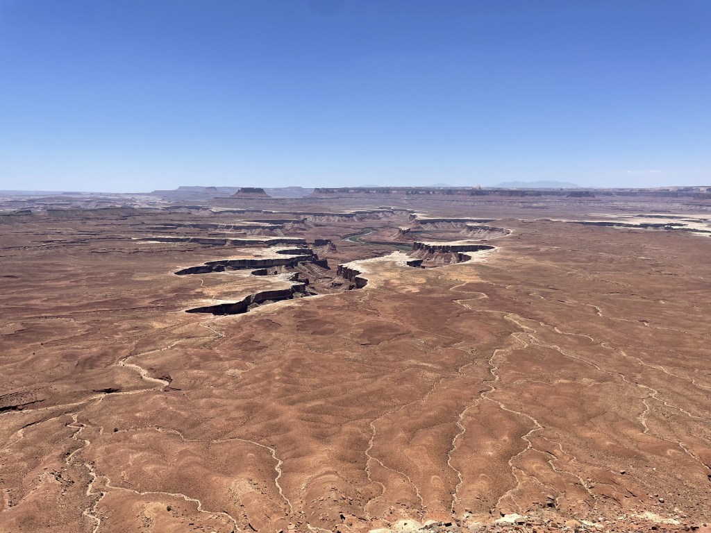
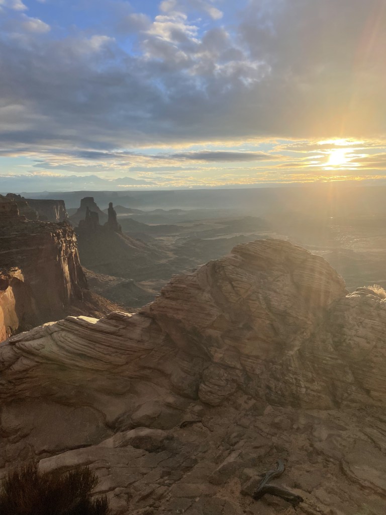
What to do at Island-in-the-Sky
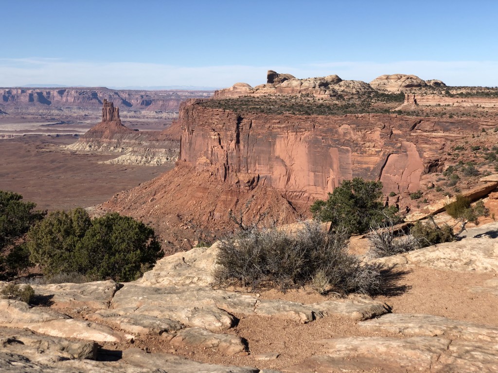
As the most frequently visited area within Canyonlands, the Island-in-the-Sky is packed with incredible overlooks and some other famous natural landmarks. This is the only area in the park that consists of a paved two-lane road with large parking lots and restroom facilities that are scattered throughout. Island-in-the-Sky Road follows along a canyon peninsula where on either side you have breathtaking views of the canyons that were formed by the two major rivers below (the Green & the Colorado) until they combine into one river.
There are a bunch of pullouts along this road that lead to overlooks. They all offer something a bit different, so I would just recommend checking out as many as possible. Not all of them require hiking, but there’s definitely plenty of trails to choose from. During cooler times of the year, off in the distance you can see mountains capped in snow from most of the viewpoints.
Some shorter hiking trails in this area include:
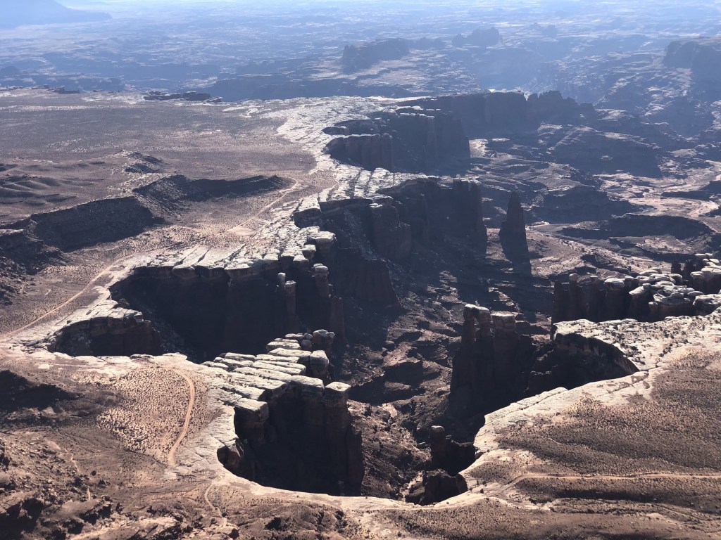
- The Mesa Arch is an extremely popular one, especially at sunrise when for about 15-minutes each morning the sun shines on the underside of the arch giving it a glowing gold effect.
- The Schafer Canyon Overlook is unique, which stares out at a windy zig-zag road that leads down to the canyon floor. If you have a high-clearance vehicle, you can actually take this road down there and drive around the entire Island-in-the-Sky!
- To the west is Whale Rock and the Upheaval Dome (an ancient creation for which scientists have a couple theories as to how it was formed).
There are only a few longer hikes (more than 3 miles in length) in this district.

What to do at Needles
Needles sits on the southeastern side of the park, roughly an hour’s drive from Moab. It is a bit more remote than the Island-in-the-Sky region and offers a much different experience. Packed with a web of intertwining hiking and biking trails, this place makes for a wild adventure that you can customize to meet your desires. The Needles region has the most backcountry camping spots and some larger zones available. The roads beyond the major campground near the entrance and major trailheads require a high clearance vehicle. (Note: you can rent a jeep in Moab!)
Hikes vary in length from less than a mile to multi-day backpacking trips, so take a look on a map to see where specific landmarks are located when you plan and book your adventure. Some of Needles attractions include:
- Cave Spring, Cowboy Camp, & Rock Markings
- Roadside Ruins
- Angel Arch
- Castle and Fortress Arches
- Druid Arch
- Chesler Park
- Confluence Overlook
- Lost Canyon
- Devil’s Kitchen
…and a lot more, but you’ll have to do deeper research into the area. I haven’t had the opportunity to explore here because I’ve never had an off-roading vehicle. Check specific trails for rules on mountain biking, and if you’re driving, be sure to watch for cyclists. Dogs are really not allowed back here at all.
One day I’ll make it to this area and I’ll be sure to tell you all about it.

What to do at The Maze
This place seems to be the real off-road lover’s paradise, packed with miles of rugged roads that require a high-clearance vehicle. Three hours away from Moab, this is the most remote area within Canyonlands, and the closest towns which offer restaurants, gas and groceries are Hanksville, at 1.5-hour drive to the west, and Green River, a 2-hour drive to the north. Access to the Maze region requires driving through the Glen Canyon National Recreation Area, passing by the Hans Flat Ranger Station at its western border. See the Maze map for backcountry camping options and keep in mind you must request a permit for overnight recreation in advance (walk-up spots are also available from the visitor centers, but keep in mind there is no visitor center on this side of the park, only the ranger station). You can inquire further from the Hans Flat Ranger Station or from the office in Moab.
In addition to needing a 4WD vehicle, many of the hiking trails are difficult, and require some basic navigation and/or rock-climbing skills. It looks like a lot of the trails out here are longer in distance (a minimum of a few miles), so be sure to bring lots of water. Some notable spots include the Maze Overlook, Harvest Scene (rock art), Doll House, Chocolate Drops, Horse Canyon and Horseshoe Canyon (these are two different places).
By driving your off-roading vehicle through the Maze region of the park, you can also access the satellite region of Canyonlands, called Horseshoe Canyon.
What to do at Horseshoe Canyon
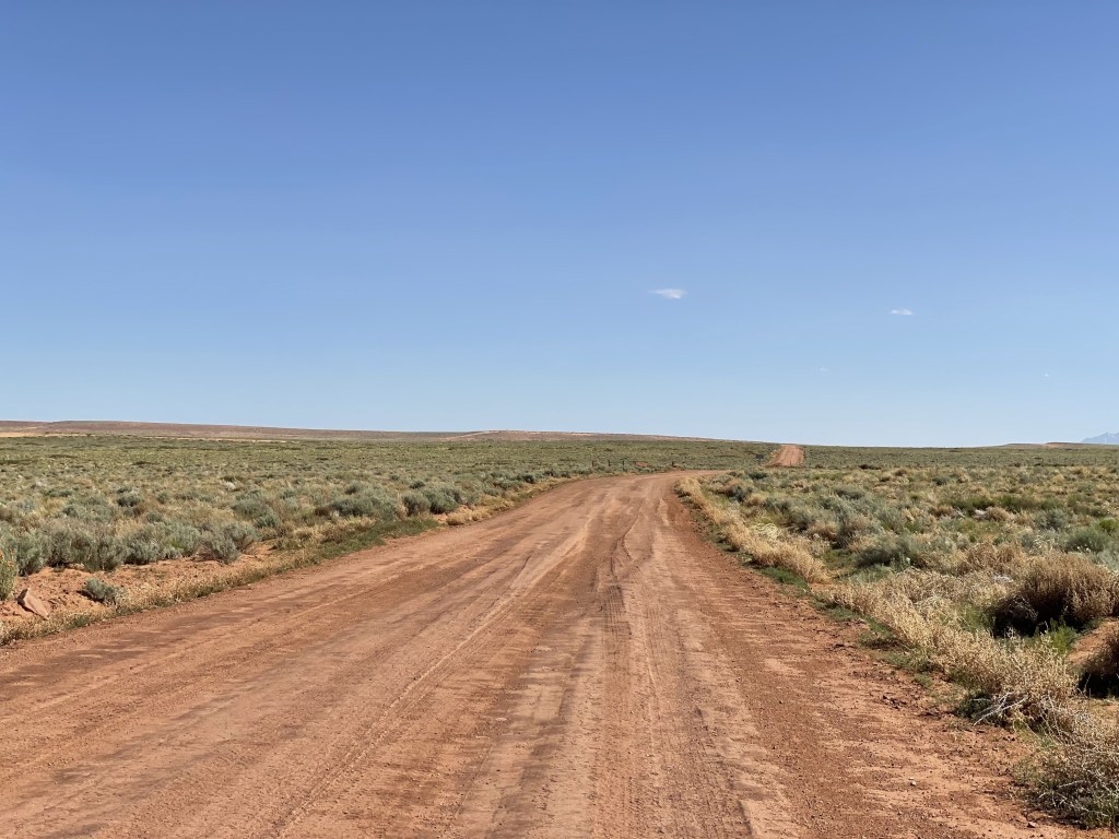
This area is easier to get to than the Maze, but it draws a much different crowd. One of the largest collections of pictographs and petroglyphs in North America can be found in this canyon. There are three total access points. It is accessible from either end of its single hiking trail from the east, which is on the northwest border of Glen Canyon National Recreation Area (which divides this satellite area from the rest of Canyonlands). Its sole western access point is down an unpaved (but mostly well-maintained) road that takes about an hour and a half to drive to from Green Valley. There is no camping in this satellite region of the park, but there are dispersed options nearby.
Horseshoe Canyon primarily consists of one out-and-back hiking trail, with a round trip total of 7 miles (roughly 3.5 miles one-way). All the images etched onto the canyon walls as well as the area’s natural beauty can be seen from this single trail. Get started learning about the history of these canyons by checking out the Canyonlands National Park website page about Horseshoe Canyon.
The dirt road to the canyon is long and mostly-maintained, there were some areas that were a little more rough and I didn’t give myself enough time to drive all the way out there, so I will have to try again some other time. A high-clearance vehicle is not necessary but will definitely shorten the commute. This is what most of the road looks like:

My thoughts
Whether you’re looking for adventure or just want to spend a few hours staring out the window at some really cool rocks, there is something here for you somewhere. The viewpoints from the Island-in-the-Sky are incredible, and the canyon is truly just so epic from up there. It makes you feel so small and insignificant to stare into the abyss that is Canyonlands.
I would highly recommend the Upheaval Dome hike to the second outlook, which I really enjoyed. This is a park I look forward to returning one day when I have a high-clearance vehicle (especially to go down the road at the Schafer Overlook), and I hope to go backpacking in the Needles and/or the Maze region at some point when the weather is right. It’s a really big park and I haven’t fully given it the attention it deserves.
Have you been to Canyonlands National Park before? Were you able to go to any of the more remote districts? What do people need to see? Let me know in the comments below!
Happy traveling! 😊
(And always remember to follow #leavenotrace principles!)
❤️
(this post was last edited and updated on February 7, 2025)


Leave a comment