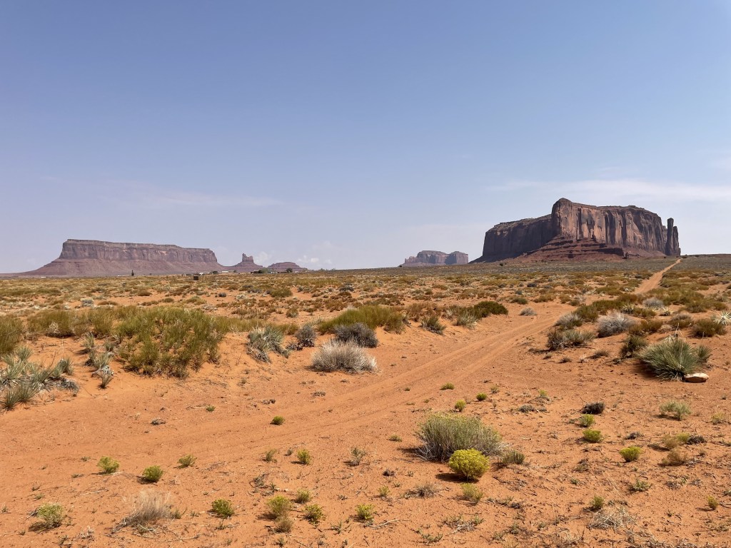
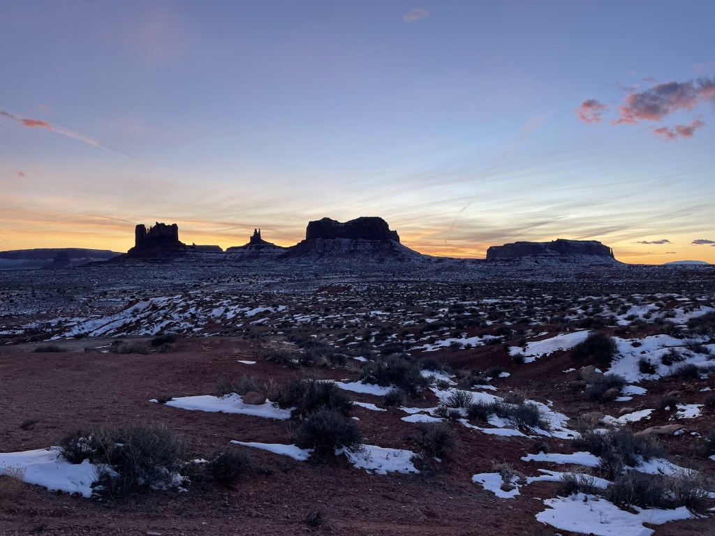
In the middle of one of the most remote areas of the contiguous 48 states sits Monument Valley, an epic display of Mother Nature’s ability to create, and an infamous landmark which jets up out of a seemingly endless and unforgiving red rock desert. Yet, despite weather patterns complicating life here, people have been thriving on these lands for thousands of years, leaving behind clues as to how they did it, and the decedents of those individuals carrying their legacy through today. Can you imagine what it would’ve been like to live here without modern amenities like running water and air conditioning?
Navajo Nation primarily sits in 3 different states, with the majority of the land being inside the state of Arizona and parts of New Mexico, along with a portion of the southern border of Utah (it also touches Colorado at the Four Corners). It is the largest of all Native American land reservations. [Note that I reviewed many different maps, but the New Mexico region boundaries are inconsistent, which may result in some minor inaccuracy later on in this post.] The Navajo people began operating a modern government in the 1920s upon the discovery of oil in the region, and named their capital city, Window Rock, AZ. In the 1990s, they reorganized how they operate to reflect a three-tiered system, which includes executive, legislative, and judicial branches much like that of the official US government. (For a little more about the history of Navajo Nations, follow this link to their official “History” web page here.)
While totally deserving, Monument Valley does not hold the status of a national park as it is considered a Navajo Tribal Park; although, there are a few other official US National Monuments inside the reservation. The Navajo people are very protective of the land they call home (can you blame them?), and they take many precautions to ensure that visitors respect it as much as they do. Many famous landmarks will require visitors to book a private tour with a guide or obtain a permit in advance to access.
Cell phone reception all over the reservation is spotty. Some long stretches of road have no signal, as well as in canyons and certain sides of mountains (although much of the region is relatively flat). I would definitely recommend downloading your music and podcasts before you go driving out there if you prefer to have something to listen to on the road, as well as downloading a map of the region or at the very least print out a map you can reference in the event you are lost. When visiting remote destinations, it is always recommended that you know where you’re going before you get there.
When to go and how long
Because the majority of this region is desert, it might be best to avoid summertime unless you are just passing through and looking for a quick pitstop and not planning to do many outdoor activities. Summer temps often exceed 100 degrees F (~38 C). Don’t go anywhere without a gallon of water in your car for emergencies. While storms are still uncommon, the region does occasionally see monsoons during this time of year.
Fall, winter, and spring are all honestly pretty great in my opinion but for much different reasons.
Early- to mid-fall can still be pretty warm still but more tolerable than the summertime, and as the season goes on it actually gets pretty nice out there. Along with mid- to late-spring, this is a good time for many outdoor activities (like hiking, horseback riding, or biking). Roads are clear and temperatures are usually not extreme.
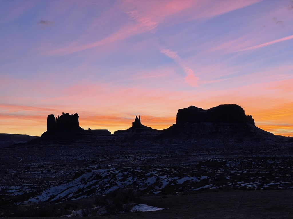
Winters are very cold and often windy, but gorgeous on a completely different level. While uncommon, the desert does occasionally receive snow. Something about the way the colors contrast; the thin dusting of bright white snow blanketing the floor, wrapping around the vertical red cliff faces… it’s a work of art. Precipitation is generally uncommon in the desert, so unless you’re a photography enthusiast who’s been watching the weather patterns and looking to get some epic shots of the natural beauty with a dusting a snow, or you’re just lucky, you likely will not see this happen during your visit. And again, it’s cold, so you probably won’t want to be out of your car for long even if you are there.
For a pitstop in Monument Valley, I would recommend a half-day if the welcome center is open (they close during inclement weather, like snowstorms) and you can do a tour, but for some deeper exploration into the surrounding area, a few days might be a good start. Lovers of the outdoors or indigenous American history could probably enjoy several days driving around and exploring different landmarks in the area.
Where to stay
Services in general are infrequent in this area of the country. Gas stations are miles apart, and there are only a few communities with major hotels. Where and if you stay in the area will depend entirely on what you are planning to do during your visit. The following are a few communities with lodging options and their drive times from Monument Valley specifically (which sits in the northern part of Navajo Nation near the Arizona/Utah border):
- Oljato-Monument Valley, Navajo Nation, Arizona/Utah border (within 5-10 minutes of park entrance)
- Kayenta, Navajo Nation, Arizona (30 minutes to the southwest)
- Tuba City, Navajo Nation, Arizona (1.5 hours to the southwest)
- Tuba City is the largest of the communities inside the region
- Chinle, Navajo Nation, Arizona (about 2 hours to the southeast)
- Window Rock + Fort Defiance, Navajo Nation, Arizona (3 hours southeast)
- Window Rock is the capital of Navajo Nation
The following cities are a bit larger and sit roughly on or near the Navajo Nation boundary, along with their travel time to/from Monument Valley:
- Page, Arizona (2 hours to the west)
- Mexican Hat, Utah (30 minutes to the northeast)
- Bluff, Utah (1 hour to the northeast)
- Cortez, Colorado (2.5 hours to the northeast)
- Durango, Colorado (3 hours to the northeast)
- Farmington, New Mexico (3 hours to the east)
- Flagstaff, Arizona (3 hours to the southwest)
- Gallup, New Mexico (3 hours to the southeast)
Many of these towns also have large campgrounds with RV hookups. Few services are available in between major cities. This is a very remote region of the country.
If you are solely passing through to see Monument Valley, cities that are a few hours away in your goal direction may be the best option for you.

How to get to and around the area
You will likely be driving your own vehicle or renting one.
Public transportation is limited but you may be able to find private bus tours that meet your needs, although there are local busses in some communities. There are a handful of small airports inside Navajo Nation but I was not able to find any commercial flights, which leads me to believe there are no public airports.
Nearest regional airports to Monument Valley are all a few hours away:
- Page, Arizona (2 hours west)
- Flagstaff, Arizona (3 hours southwest)
- Cortez, Colorado (2.5 hours northeast)
Nearest international airports to Monument Valley are all about a half-day drive away:
- Phoenix (5 hours southwest)
- Albuquerque (5.5 hours southeast)
- Las Vegas (6.5 hours west)
- Salt Lake City (6.5 hours northwest)
I’ll provide you with some road trip options from these major airports at the end of the post.
Bike-packing and thru-hiking are possible options to get around the area but this would only apply to a very niche group of individuals. You’re most likely either road tripping through this area from elsewhere, or renting a car in whichever city you fly into.

Food and money
Options are limited because there are very few services in this part of the country. Aside from a few gas stations, most towns just have a few fast food or diner-style restaurants, a couple hotels or small inns, and a general grocery store.
Prices may be higher near Monument Valley (like in the Kayenta or Oljato areas), but the views will be unmatched and you’re supporting the local communities. Aside from this area, most food prices seem to be pretty average. Lodging can get pricy depending how close you are to the major landmarks.
Private guided tours of many varieties are available and can easily run over $100 per person depending on the length of the tour. Some of the benefits of doing this is that you are getting information about the places you are looking at from a resting heart rate (unlike hiking). Not all guides are the same, and if you think yours did a good job, it is always recommended that you tip them for their services. I believe having the context and commentary about these places directly from someone who considers this land “home” is priceless.
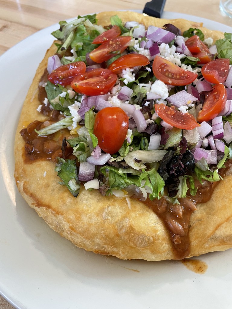
Regardless of where you order one, try a fry bread somewhere and/or a Navajo Taco (also sometimes called an Indian Taco). Of all the different restaurants/cities from which I’ve ordered one, Amigo Cafe in Kayenta was my favorite (which is conveniently close to Monument Valley, and recommended to me by a local).
To my understanding, the story behind the fry bread is that during the 1800s, tribes were forced to relocate to New Mexico (called the “Long Walk”) by the US Government. They were provided with rations of flour and other basic ingredients during this time for survival by the US Government which the people used to create fry bread. While mouthwateringly delicious, fry bread is not healthy and has been thought to be a cause for an obesity epidemic in the area. Fry bread is recognized as a symbol of resilience and unity by the people, but also carries with it memories of pain and hardship.
(Follow this link to a longer article about fry bread by the Smithsonian Mag.)
What to do in Monument Valley Navajo Tribal Park
This place is literally this emoji, 🏜️, and is perhaps one of the most popular attractions in all of the American Southwest. The official Monument Valley website is linked here.
For many reasons, Monument Valley is extremely special, and it is recognized as such by the people that live here and further confirmed by nearly every visitor that passes through. It is featured in many movies (remember Forrest Gump’s run across the country?) and really, just an absolute icon. You could easily spend a half-day here if you plan ahead and the weather conditions allow for the visitor center to remain open.
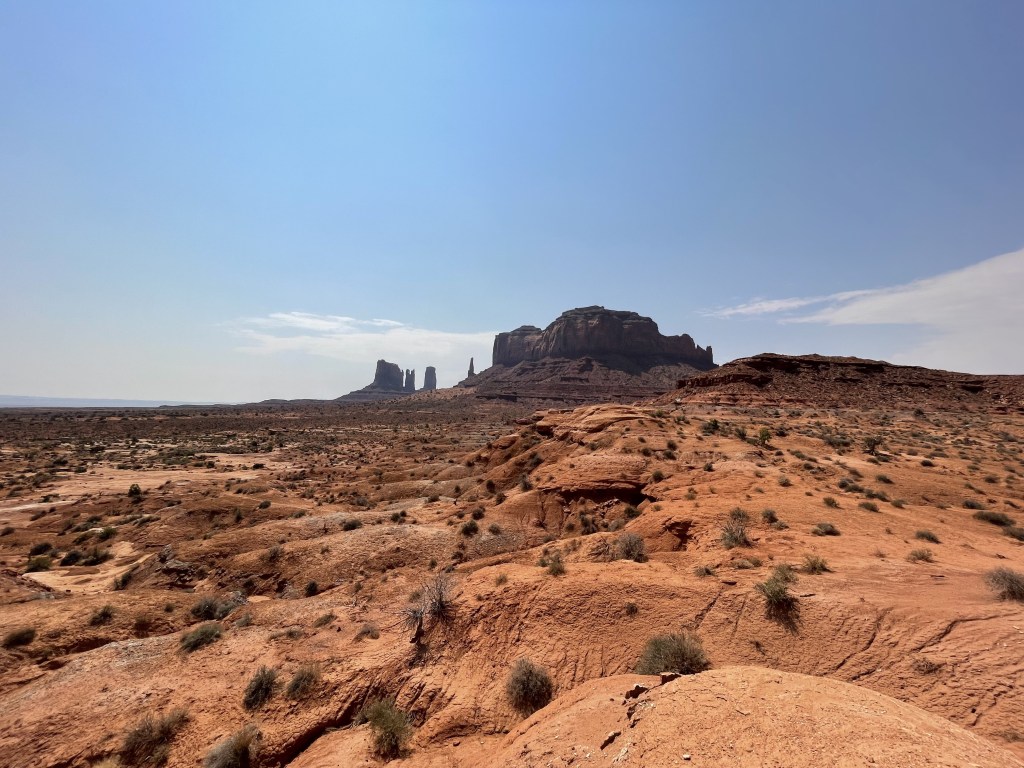
Highway 163 runs between the communities of Kayenta, Arizona and Bluff, Utah through the northern region of Navajo Nation. This road is typically always open, and has absolutely incredible views of the famous landmark that is Monument Valley. There is no toll to drive this public road, so even if the visitor center is closed, you can still enjoy this destination. Roadside pullouts are frequent and there may be some local sellers along the route with small art and souvenir stands. Don’t miss your opportunity to hop out of the car at the famous Forrest Gump viewpoint and get your “running” photo next to the road! Do not stop traffic and stay out of the middle of the road– there is a little dirt platform area off to the side for a safer option. Some viewpoints are slightly off the main road and offer different angles for viewing.
Park entrance is $8 per person.
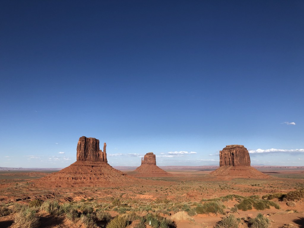
The very large visitor center at the park is home to a cafe, a massive gift shop with all kinds of Native American artwork and other souvenirs, a lodge, and some informational exhibits. Much of this building has windows with direct views of the famous “mittens” off in the distance. Check the hours in advance, as they vary by season and day of the week. Park operation can often be affected by weather. While you can absolutely still see the sights without visiting this welcome center from the main highway, this is definitely where some of the best views are.
Walk the Wildcat Trail, a lollipop-shaped loop around the West Mitten Butte that is mostly flat and about 4-miles in total distance. This will give you a closer look at these beautiful rock monstrosities. The trailhead is just north of the visitor center and you will be required to pay the entry fee to access it. Dogs on a leash are allowed.
Drive the 17-Mile Drive, a scenic road through the valley, as this provides some of the most epic views of all the different named rocks protected by the park. It is recommended to have a high-clearance vehicle for this journey, although plenty of individuals have successfully completed this with a sedan. Attempt at your own risk and know that rescues in case of emergency will be time consuming as resources are limited in this region.
There are some really cool guided tours available of Monument Valley which vary in length, price, time and destination. Vehicle options through the backcountry include jeep tours, a safari-style vehicle or an enclosed SUV. Horseback riding and photography specific experiences are also available. Follow this link to see a list of park approved providers.
The View Hotel is located directly in the park next to the visitor center. There are hotel rooms, private cabins, and a campground. The location is spectacular …but I had difficulties finding availability information or booking online.
***Note that this destination is NOT a US national park and is operated as a Navajo Nation Tribal Park.***
Other things to check out INSIDE the Navajo Nation boundary
(Note that all distances are from Monument Valley as a reference point, each attraction resides within or sits on the Navajo Nation boundary. For the most part, they are listed in order of proximity to each other.)
- Four Corners Monument (1.75 hours to the east)
- quick pitstop for an opportunity to stand where 4 states meet all at once! (Arizona, New Mexico, Colorado, and Utah)
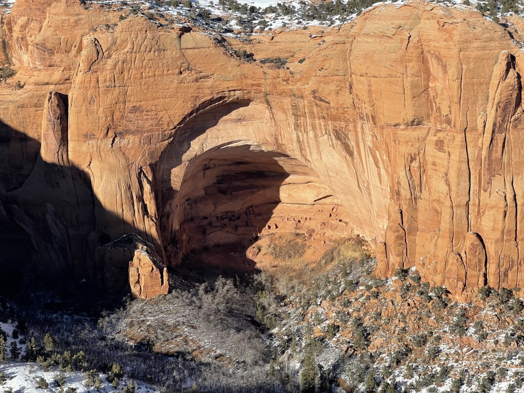
- Navajo National Monument (1 hour southwest of MV)
- preserves some ancient cliff dwellings and offers views of it both from a distance and up close
- views are by hiking trail, a total of 3 self-guided shorter/flatter walking trails to outlooks all roughly 1-mile each, more strenuous hikes down to cliff dwellings by guided tour only, official NPS web page linked here
- camping available
- Explore Navajo Interactive Museum (1.75 hours to the southwest in Tuba City, Arizona)
- exhibits about Navajo people, culture, ceremonies, history and land
- hours vary by season and day of the week, more info linked here
- Moenkopi Dinosaur Tracks (1.75 hours to the southwest in Tuba City, Arizona)
- check out some fossilized dinosaur tracks which shed light on what these lands might have looked like thousands of years ago
- quick pitstop
- Antelope Canyon (2 hours to the west near city of Page, Arizona)
- famous red rock slot canyon, appears different depending on time of the day due to the way the light floods into the slots, popular for photography
- guided tours are mostly required to access this landmark, see list of approved providers here
- Historic Navajo Bridge (2.75 hours to the west at the boundary of NN near Page, Arizona)
- one of the first bridges in the region across the Colorado River, now a pedestrian bridge which parallels the New Bridge (for vehicles)
- walk across bridge and check out the beautiful canyon views, official NPS web page linked here
- Grand Falls, Arizona (3.5 hours to the southwest near Flagstaff, Arizona)
- *Grand Falls is currently closed to the public* due to disrespectful tourists, and it is unclear if/when this sacred site will reopen in the future. 😔
- incredible multi-tiered desert waterfall, looks like a chocolate fountain
- high-clearance vehicle may be required, be aware of flash floods and muddy roads
- Rainbow Bridge National Monument (western wilderness of MV, northeast of Page, Arizona unknown travel time)
- exists in the backcountry, access is complicated and requires advanced planning, requires use of a boat via Lake Powell and a 2-mile hike
- recommended only if you have watercraft and backcountry experience
- Canyon de Chelly National Monument (about 2 hours southeast near city of Chinle, Arizona)
- beautiful red canyons with vertical cliff faces and ruins of ancient communities
- unless you book a tour, you will only be able to check out the 9 total lookouts the scenic drive on the north and south rims and hike the White House Trail if it is open (seasonal)
- guided tours are required for access to a lot of this park, see list of approved providers here or learn more on the NPS official page; tours include hiking, horseback riding, and some vehicle tours
- camping available
- Window Rock, Arizona (3 hours to the southeast at the Arizona and New Mexico border)
- visit the Navajo Nation Museum, Library, and Visitor Center; check out the exhibits that provide insight into the culture and history of the Navajo people and the land, hours vary by day of the week, more museum info linked here
- there is also a zoo and botanical garden nearby, more zoo info linked here
- go check out the Window Rock Navajo Tribal Park
- visit the WWII Memorial which honors the celebrated Code Talkers
- go shopping at the flea market, Ch’ihootso Indian Market Place, open daily 830a-4p
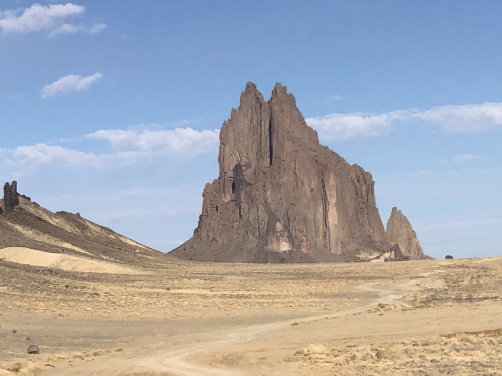
- Shiprock (3 hours to the southeast by town of Shiprock, New Mexico)
- permit required to recreate on this land, but otherwise you can see the rock from the highway as you are driving by to Farmington or Albuquerque/Santa Fe
- there really isn’t a website for this rock but you can learn a little more about it here
- Bisti/De-Na-Zin Wilderness, New Mexico
- otherworldly rocks and hoodoos provide epic hiking and photography opportunities
- hiking and photography tour information linked here
- camping available
- learn more about the area boundary on the BLM web page linked here
More stuff to check out just OUTSIDE Navajo Nation (within a 5-hour drive of Monument Valley)
This entire region of the country is packed with so many outdoor activities, you might have a difficult time picking what exactly you want to do. While there are tons of great options inside Navajo Nation, there are even more just outside the boundary, as well as more opportunities to learn about the indigenous cultures native to this region. Consider checking out any of these places while you’re in the area… (it makes for a great road trip!) 😊
*Colorado cluster*
- Mesa Verde National Park, Colorado
- 3.5 hour drive to the northeast of MV
- recognized as an UNESCO World Heritage site
- guided tours of incredibly well preserved cliff dwelling community ruins, advanced reservations are required for tours, hiking required
- Canyons of the Ancients National Monument, Colorado
- 2.5 hour drive to the northeast of MV
- self guided exploring of ruins, hiking required
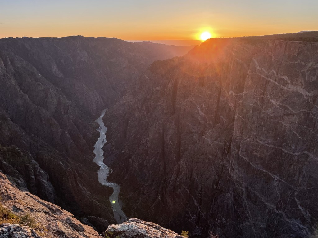
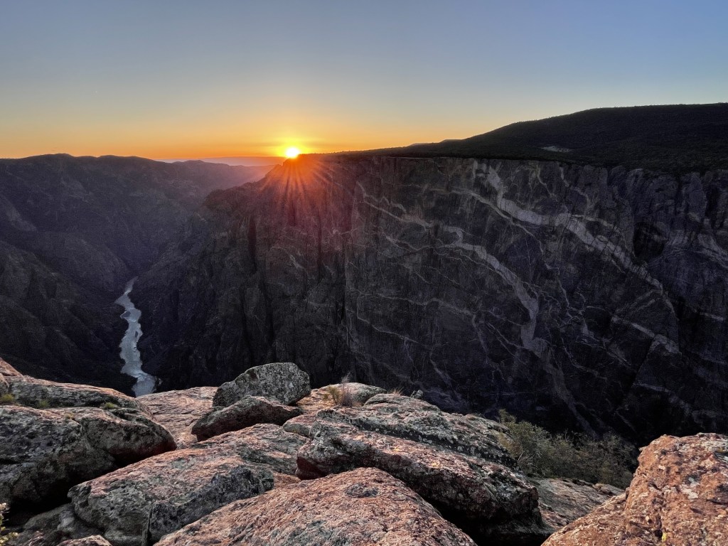
- Black Canyon of the Gunnison National Park, Colorado
- 5-hour drive to the northeast of MV
- scenic drives with mini hikes on south rim and some longer options to the north, get face to face with the epic vertical dark-hued cliffs which greatly contrast the hot deserts of the southwestern region
- for more information, my detailed post about visiting Black Canyon of the Gunnison is linked here

*New Mexico cluster*
- Aztec Ruins National Monument, New Mexico
- about a 4.5 hour drive to the east of MV
- part of a UNESCO World Heritage site
- explore Aztec ruins and visit the museum
- near small city of Farmington, New Mexico
- Chaco Culture National Historic Park, New Mexico
- about 4-hour’s drive to the southeast of MV
- part of a UNESCO World Heritage site
- visit ancient ruins up close, popular for hiking and biking, dogs ok on trails as long as they are on a leash and you clean up after them
- El Malpais National Monument, New Mexico
- about 4-hour’s drive southeast of MV
- diverse range of volcanic landscapes, scenic drive and hiking trails, the Spanish “el malpais” translates to “the badlands”
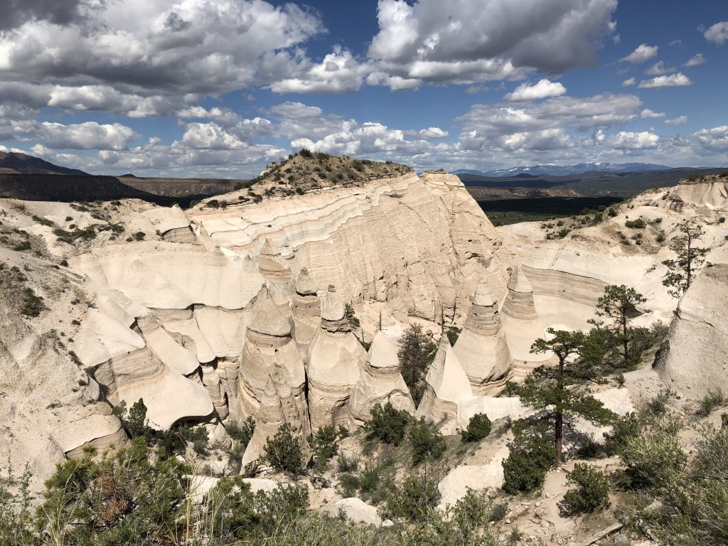
- Kasha-Katuwe Tent Rocks National Monument, New Mexico
- about 6-hour’s drive to the southeast of MV
- unique hoodoos and canyons for hiking
- a timed reservation through the NPS as well as a Cochiti Pueblo Tribal Access Pass are both are required for entry
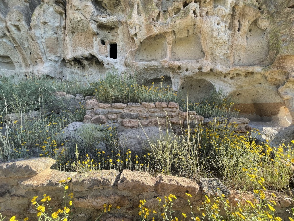
- Bandelier National Monument, New Mexico
- about 6-hour’s drive to the southeast of MV
- hike to and inside formerly occupied cliff dwellings
- Albuquerque, New Mexico
- about 5-hour’s drive to the southeast of MV
- lots more Native American stuff in this area, like viewing rock art at Petroglyph National Monument
- infamous Hot Air Balloon festival in October, weed tourism, all things Route 66
- check out my detailed post about visiting Albuquerque and Santa Fe, NM linked here
*Arizona cluster*
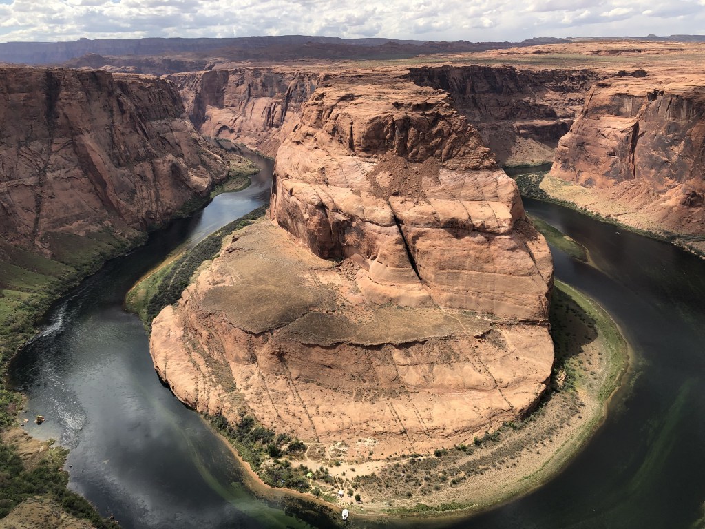
- Horseshoe Bend State Park + Page, Arizona (city)
- 2 hour drive from MV near Arizona/Utah border, sits near northwest border of NN
- Horseshoe Bend is an extremely famous major landmark, gets busy regardless of what time you go but may be quieter early morning and shortly after sunset
- includes a mostly-flat walk (3/4 mile one-way) to reach the viewpoint, guardrails in place but you can find lookouts without them away from the main viewing area
- Wupatki National Monument, Arizona
- just under 3 hours to the southwest of MV
- ancient pueblo communities, walking required to see them up close, some take 5 minutes to access, others may take hours
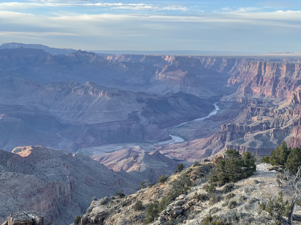
- Grand Canyon National Park, Arizona
- about 3.5 hours southwest of MV to reach the South Rim
- epic canyon views with hiking opportunities
- camping available
- my detailed post on visiting the Grand Canyon is linked here
- Walnut Canyon National Monument, Arizona
- 3 hours to the southwest
- includes hiking trails to some ancient ruins of cliff dwellings (Rim Trail = easy, Island Trail = difficult, both less than 1-mile)
- Sunset Crater National Monument, Arizona
- 3 hours to the southwest of MV
- volcanic lava fields and scenic views via hiking or driving
- Sedona, Arizona (city)
- incredible red rock wilderness with epic outdoor opportunities, also filled with indigenous history, so many options you will have a difficult time choosing
- the city basically sits right in the middle of the canyons so there are great views just about everywhere
- 3.5 hours to the southwest of MV
- for more ideas in this area, check out my detailed post about Sedona linked here
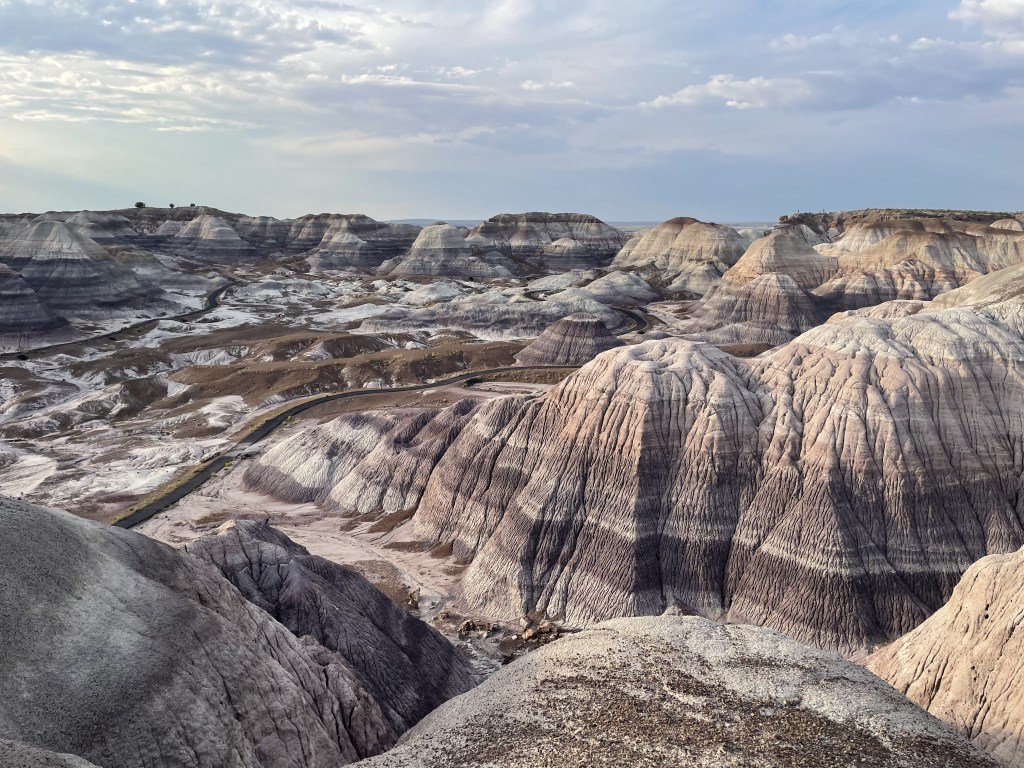
- Petrified Forest National Park, Arizona
- just over a 3 hour drive from MV, just outside the southern border of NN, makes a good pitstop if heading into New Mexico
- otherworldly display of Mother Nature’s work, multicolored landscapes and trees turned to stone, also home to a few small indigenous ruins

*Utah cluster*
- Glen Canyon National Recreation Area, Utah
- large protected region packed with viewpoints and opportunities for outdoor adventuring, including water activities and scenic drives
- 2 hour drive to the west of MV
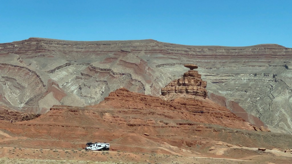
- Mexican Hat, Utah (city)
- about a 30-minute drive from MV, just outside the northern border of NN
- famous rock landmark is just off to the side of Highway 163 down a well-maintained dirt road, visible to the east from the highway just north of town
- dry campsites nearby, and amenities in the community of Mexican Hat include a gas station, a restaurant, San Juan River access, several small inns/lodges and camping options (RV hookups available)
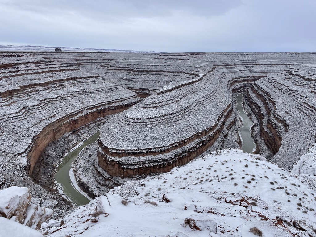
- Goosenecks State Park, Utah
- about a 40-minute drive from MV, just outside the northern border of NN
- unique three-point-horseshoe river canyon lookout spot, a bit smaller than Horseshoe Bend but still impressive
- campsites available on a first-come, first-served basis
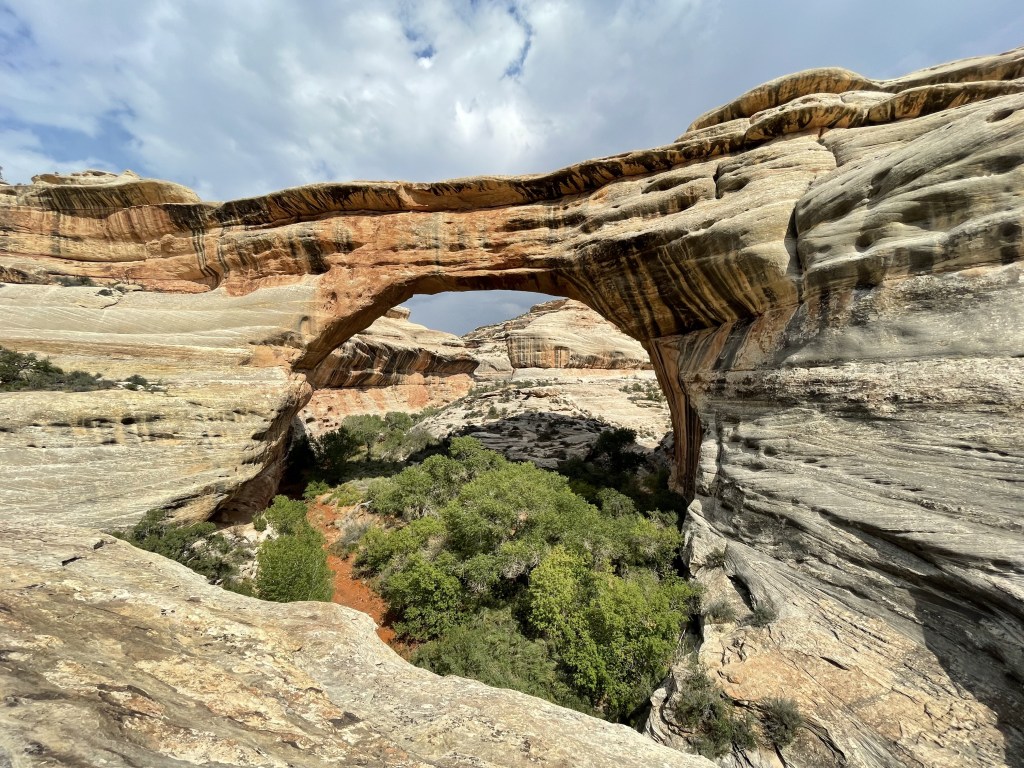
- Natural Bridges National Monument, Utah
- 1.5 hour drive to the north of MV
- three major natural arches with a variety of viewpoints, visitors can hike closer for a better view, also home to some ruins of cliff dwellings
- campsites available on a first-come, first-served basis
- Bears Ears National Monument, Utah
- a protected area to the north of MV that encompasses a large portion of southeastern Utah; Natural Bridges NM, Goosenecks SP, and many other landmarks technically sit inside the boundary
- follow this link to see a map of the area referred to as Bears Ears NM
- Hovenweep National Monument, Utah
- 2 hour drive to the northeast of MV, near Utah/Colorado border
- ruins of six villages estimated to be dated from about 1200 to 1300 AD
- one campground w/ about 30 campsites, follow this link to make reservations at Hovenweep Campground
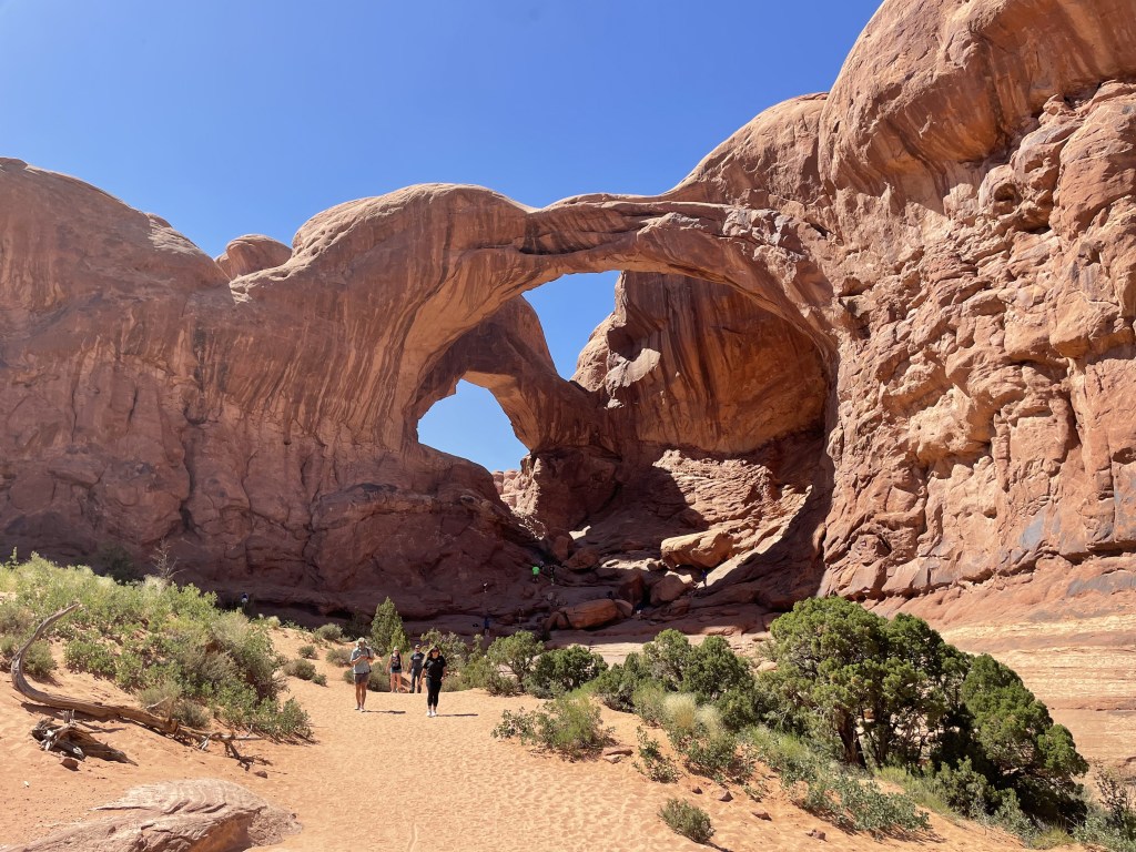
- Arches National Park, Utah
- 3 hour drive directly north of MV, basically in the city of Moab
- drive the road through the park, lots of pullouts with scenic lookouts, epic hikes to arches all over the place
- check out my post about visiting Arches NP linked here
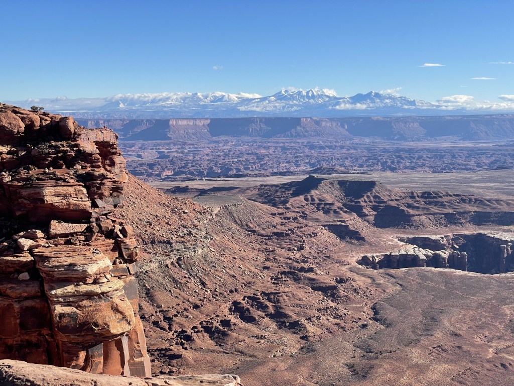
- Canyonlands National Park, Utah
- 3.5-hour drive directly north of MV, near city of Moab
- check out the “Island in the Sky” scenic drive with epic viewpoints of the canyon below, some short hiking trails scattered along the route
- also nearby, check out Dead Horse Point State Park
- check out my detailed post on Canyonlands NP linked here
- Capitol Reef National Park, Utah
- 3.5-hour drive to the northwest of MV
- protects more red rock area as well as an exposed geologic fold which sheds light on what this area looked like millions of years ago, as well as some more recent rock art and an orchard built by early western pioneers (you can even go apple picking in the right season!)
- for more information, my detailed post about visiting Capitol Reef National Park is linked here
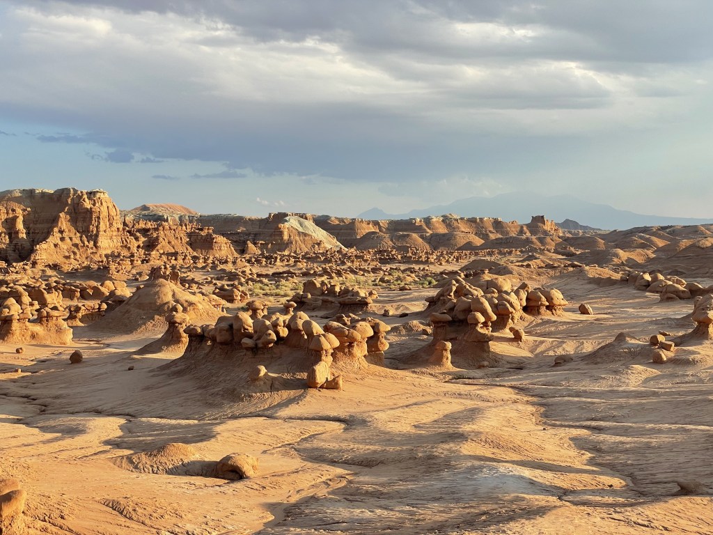
- Goblin Valley State Park, Utah
- about a 4-hour drive to the north of MV
- take a short walk around some otherworldly red rock hoodoos in the middle of the Utah desert
- Zion National Park, Utah
- about a 4.5-hour drive northwest of MV
- famous red rock canyon with various hiking opportunities
- follow this link to see my detailed post about Zion National Park
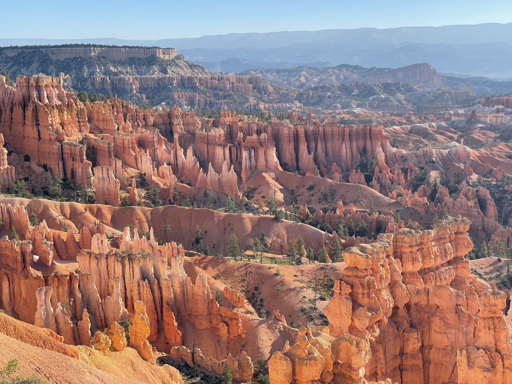
- Bryce Canyon National Park, Utah
- about 5-hour’s drive northwest of MV
- unique canyon of hoodoos you can explore, incredible photography location
- check out my detailed post about visiting Bryce Canyon linked here

Potential road trip stops en route to Monument Valley from nearest international airports
from Phoenix, Arizona…
- western route: Sedona, Flagstaff, Grand Canyon National Park (detour), Sunset Crater National Monument, Walnut Canyon National Monument, Wupatki National Monument, Tuba City, Navajo National Monument, Kayenta
- eastern route: Petrified Forest National Park, Window Rock (capital city), Chinle, Canyon de Chelly National Monument, Navajo National Monument (detour), Kayenta
from Las Vegas, Nevada…
- southern route: Hoover Dam, Grand Canyon National Park (detour), Sedona (detour), Flagstaff, Sunset Crater National Monument, Walnut Canyon National Monument, Wupatki National Monument, Navajo National Monument, Kayenta
- northern route: Valley of Fire State Park, St. George, Zion National Park, Grand Staircase Escalante National Monument, Glen Canyon National Recreation Area (major detour), Page, Horseshoe Bend, Antelope Slot Canyon, Navajo National Monument, Kayenta
to/from Salt Lake City, Utah…
- western route: Cedar Breaks National Monument, Bryce Canyon National Park, St. George, Zion National Park, Page, Horseshoe Bend, Antelope Slot Canyon, Navajo National Monument, Kayenta
- eastern route: Capitol Reef National Park (major detour), Goblin Valley State Park (major detour), Dead Horse Point State Park, Canyonlands National Park, Moab, Arches National Park, Natural Bridges National Monument, Goosenecks State Park, Mexican Hat
to/from Albuquerque, New Mexico…
- southern route: Petroglyph National Monument, El Malpais National Monument, Chaco Culture National Historic Park (detour), Gallup, Window Rock, Petrified Forest National Park, Chinle, Canyon de Chelly National Monument, Navajo National Monument (detour), Kayenta
- northern route: Petroglyph National Monument, Santa Fe (capital of New Mexico), Bandelier National Monument, Chaco Culture National Historic Park (detour), Aztec Ruins National Monument, Farmington, Shiprock, Four Corners Monument, Natural Bridges National Monument, Goosenecks State Park, Mexican Hat
My thoughts
I am so grateful that these lands are protected in their current state. I’m certainly no expert in the culture of the Navajo people, nor any Native American group for that matter, but it is to my understanding that collectively they deeply value the connection we have with nature, our creator, which in some regard appears to be forgotten by a lot of western society. We must take care of our planet for us all to survive. I think with all of the luxuries that provide us escape from nature’s worst days, we don’t often consider where we came from and how different things are now; how much the world has evolved. The Navajo people probably only offer guided tours around some of their major landmarks because they have enough experience with people who don’t know how to treat it properly, and aside from closing places altogether, that is their best defense in protecting these places.
There’s a lot of stuff in this area I haven’t had the opportunity to visit yet. Once you’re out there, the reception situation can be complicated and you definitely want to know where you’re going before you get there. Some spots I learned about while writing this post that I didn’t know about include Hovenweep NM, Canyon de Chelly NM, Chaco Culture NHP + Aztec Ruins NM, Walnut Canyon NM… and they’re all on my bucket list now!
Have you been to Navajo Nation? Did you have a favorite viewpoint of Monument Valley? Did you do any other exploring, or check out some ruins? What would you consider to be a must-see? What else would you recommend to someone who hasn’t visited yet? Let me know in the comments below!
Happy traveling! 😊
(And always remember to follow #leavenotrace principles!)
💚
(this post was last edited and updated on February 11, 2025)
keywords for search purposes: [arizona, usa] [utah, usa] [new mexico, usa] [colorado, usa]


Leave a comment